Google Maps is adding back ski trails, chairlifts and lodge markers to its maps, reinstating the information it had removed after last season in response to months of questions from skiers and snowboarders. The new layer comes back with recent data from new imagery and official resort map info available, and has the goal of showing much more accurate lines than its former self.
Early availability targets popular destinations throughout North America and Europe, including examples already spotted at Whistler Blackcomb in British Columbia, Park City Mountain in Utah, and Palisades Tahoe in California. A few chains are still missing for now, in a reminder that the rollout is underway but isn’t yet universal.
- What’s returning to Google Maps for ski areas this winter
- Why Google reversed course on ski trail mapping
- Where you’ll see it first on Google Maps this season
- Accuracy and safety considerations for ski map overlays
- How to locate the new Google Maps ski trails layer
- What it means for skiers and resorts using Google Maps
What’s returning to Google Maps for ski areas this winter
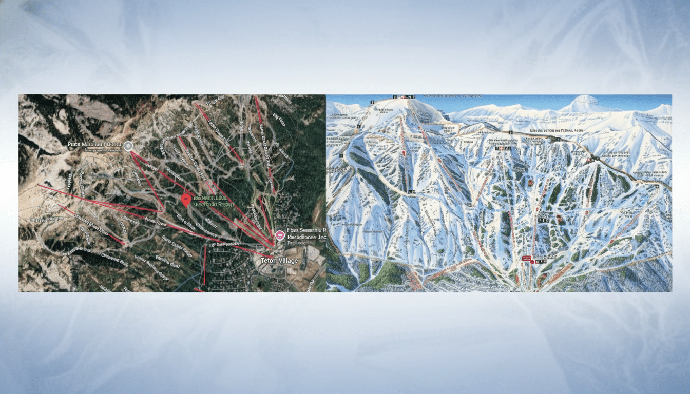
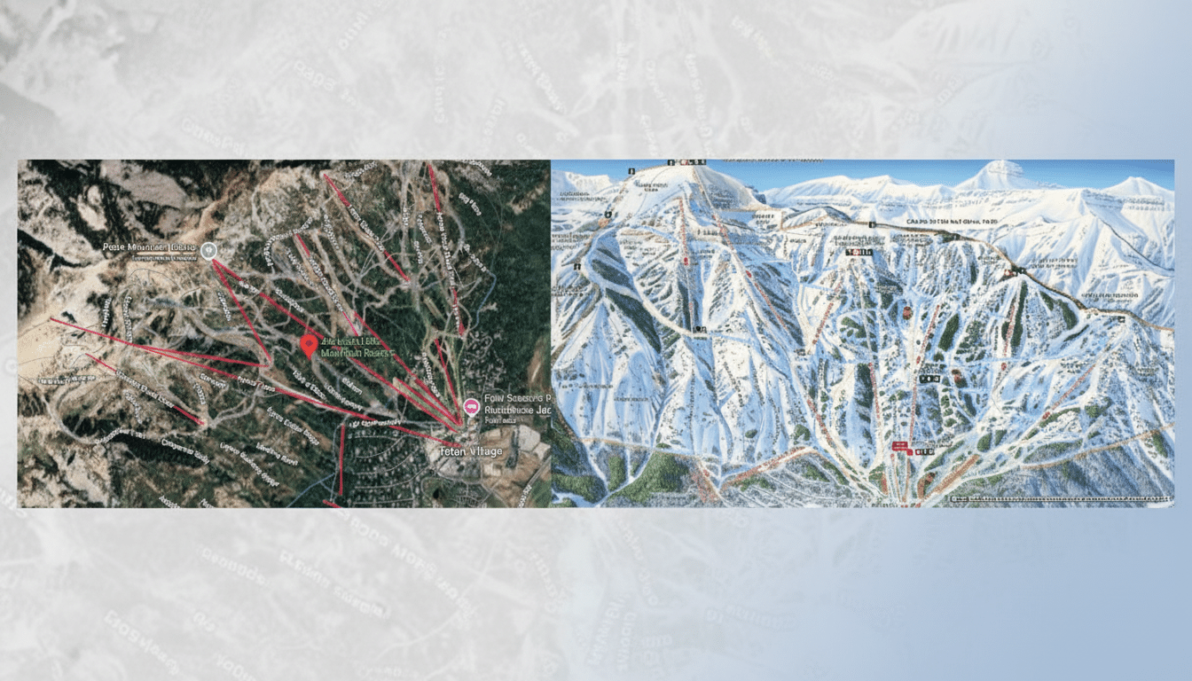
At eligible mountains, Google Maps shows easy-to-read ski runs, lift lines and lodge or base-area facilities. The company said it had reconstructed the data set with more recent aerial and satellite images and added information from maps provided by resorts. That mix will right incorrect past trail alignments that caused lift lines to zig and zag or trails no longer to correspond with on-the-ground reality after terrain changes or improvements.
As a practical matter, the overlay allows riders to see quickly how terrain links up: Where does a chair drop you? Where does a cat track end? What runs go back to home base, and so on, without toggling between apps.
Google has not specified if all resorts will feature difficulty ratings or run names at launch, so labeling may be different depending on area.
Why Google reversed course on ski trail mapping
Google had previously removed the feature, saying outdated information made it less trustworthy than official resort maps. But persistent user demand forced the company to reconsider its strategy. The decision to return was made at least in part due to feedback, a spokesperson told the ski outlet POWDER, with popular resorts taking priority first and others to follow as data becomes available.
The decision tracks with the overall growth in winter sports participation. U.S. ski areas saw a record 64.7 million visits during the 2022–23 season, according to the National Ski Areas Association, which suggested that accurate, accessible mapping is more critical than ever for trip planning and day-of navigation.
Where you’ll see it first on Google Maps this season
Coverage is expanding to popular destinations in North America and Europe. Among the first to showcase the refreshed trails and lift names are Whistler Blackcomb, Park City Mountain and Palisades Tahoe. There are some mountains that haven’t been added yet—like Red Mountain Resort in British Columbia and Hoodoo Ski Area in Oregon—implying a staged rollout as imagery and resort data are validated.
Anticipate a phased rollout: resorts with extensive digital maps and recent infrastructure changes are likely to be featured early, while smaller hills or regions where mapping resources are scarce may come later.
Accuracy and safety considerations for ski map overlays
But even with updated data, ski terrain is always changing. Groomers change up the routes nightly, wind throws snow off it, and resorts open or close runs throughout the day. Use Google Maps as a handy reference, not the last word on trail status. For the most current open/closed status, as well as the safest guidelines, please refer to official resort reports and ski patrol announcements.
Backcountry and sidecountry locations are typically found next to ski area boundaries but not maintained by the resort. Riders should check at regional avalanche centers and local advisories before leaving established areas.
How to locate the new Google Maps ski trails layer
Open Google Maps, search for a ski resort you have visited by name and zoom in on the mountain range. If the resort is supported, you’ll see mapped lift lines, runs and lodge markers overlaid onto the terrain. If you don’t see it, the area you’re in may not yet be covered — try updating your app or looking for something similar at another supported resort.
The overlay is a nice complement to other Maps standards, like driving directions to individual base areas or parking lots, and live traffic conditions during storm cycles when access can bog down.
What it means for skiers and resorts using Google Maps
For visitors, the reopening of trails and lifts eases navigation — particularly at large multi-peak resorts where it can be daunting to navigate the lift network. At resorts, the accurate depiction in Google’s default mapping tool leads to better wayfinding and discovery that unearths what a smaller resort wants unearthed, not overwriting their own digital maps.
The takeaway: Google fixed the problem, rebuilt the data and is returning snow runs to Maps in time for winter.
Coverage is not complete, but the early rollout already makes planning a day on the hill a little easier — and a lot clearer.