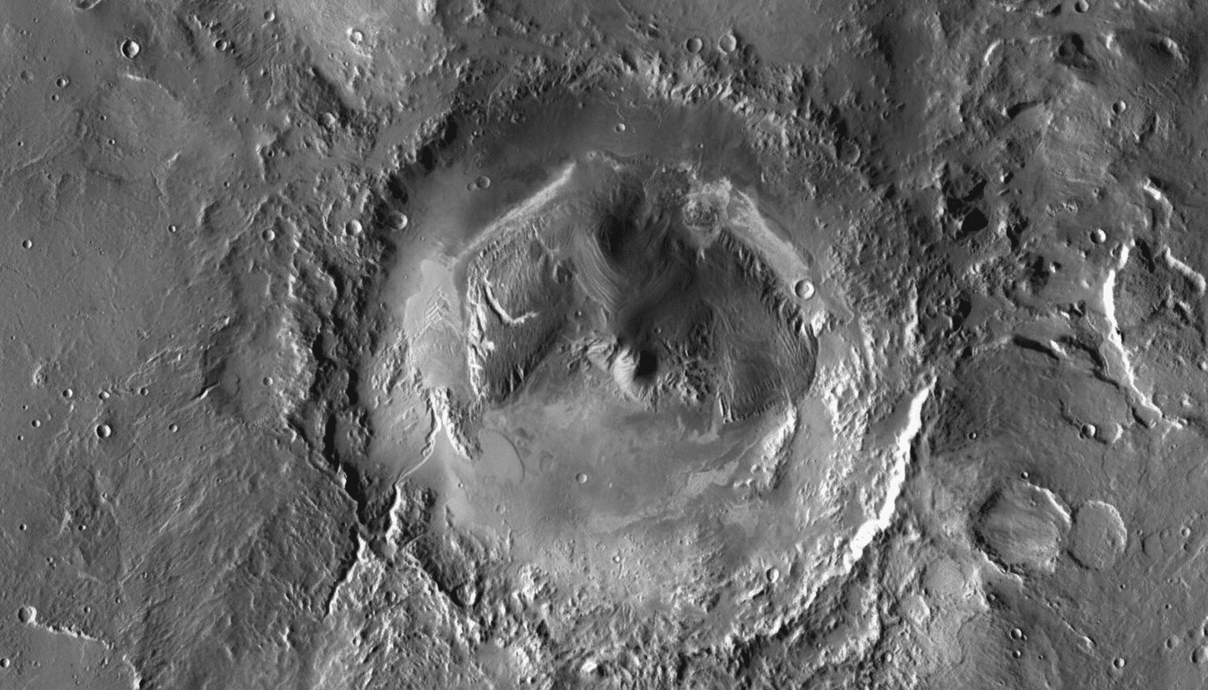
NASA’s Curiosity rover has shot a new panorama in Gale Crater, showing an old river system known as Peace Vallis in incredible detail. The panorama, which was captured from the lower slopes of Mount Sharp, combines a series of images that conjures up a quilt of layered buttes, winding channels and sediment fans that bear witness to an ancient era when liquid water flowed between them on the surface of Mars.
There are the eye-popping new pictures, yes, but also a timeline that can help scientists map how water once flowed through Gale, where it might have pooled and how long those processes lasted. It’s a rare, long-range look at Mars’ fluvial past on a world that is now dust and thin air — but under unusually clear atmospheric conditions.
A crystal-clear view across Gale Crater in new panorama
That ice chunk sits right in the middle of a pair of craters, which, like a fossilized watershed, feels more like an echo of rivers than one that was actually carved by them. Orbiters and their HiRISE and CTX cameras have mapped its channels and the broad alluvial fan where sediment spread into Gale. From Curiosity’s perspective, the mosaic fills in fine textures like channel bars and fan lobes and eroded scarps that anchor those orbital maps in on-the-rock detail.
Gale Crater is about 154 kilometers across and contains Mount Sharp (Aeolis Mons), a 5-kilometer-high mound of layered sediments. The new panorama frames that story in miniature: river-cut channels on the floor lying below, translating upslope into mudstones, sulfates and other layers that Curiosity has been reading like pages in a kind of environmental time-book. For years, the U.S. Geological Survey and mission scientists have been saying that Peace Vallis is a textbook example of sustained sediment transport by many rivers, not just one destructive flood.
What powered the water remains a debated topic. For instance, climate modelers at NASA Ames and other institutions speculate that early Mars may have had short warm periods — either generated by volcanism or impacts or so-called greenhouse pulses — that melted snowpack and fed runoff. Still others favor groundwater upwelling over a longer period of time that gradually seeped or sapped channels. The new images help add constraints on where channels converge, how deposits thin and which ridges stand out as inverted streams.
How Curiosity shot the panorama with Mastcam and ChemCam
The panorama is actually being distributed across dozens of Mastcam frames, color balanced to give an approximation of what the scene would be like under Earth-like lighting. Mastcam, which was built by Malin Space Science Systems, includes two color imaging systems of different focal lengths for distance and close-up views. Dust sticking to the lenses has been observed at Gale, and lower dust optical depth can offer factors-of-ten improvements in distant views.
To make out details at a greater distance, the team also turns to ChemCam’s Remote Micro-Imager, a telescopic black-and-white camera developed at Los Alamos National Laboratory with French partners. Best known for zapping rocks with a laser to determine their chemistry, ChemCam’s imager serves as a long-distance spotter that resolves distant outcrops and layering that inform where the rover looks next.
It’s this patchwork of multiscale imagery — wide-angle Mastcam color, telephoto detail and orbital context — that combines into a whole picture. Leaning on tonal contrasts helps emphasize the contrast between wind-shaped yardangs and water-laid beds. Lineations in the fan suggest flow directions, and ridge networks might follow mineral-filled fractures that later were more resistant to erosion.
What the rocks are telling scientists about water
Curiosity has already logged several waypoints in Gale’s aqueous history: clay-bearing mudstones at Yellowknife Bay, lakebed deposits at stops along the Murray formation, sulfates, and other hallmarks of more arid aeons higher on Mount Sharp. Levels marked on the schedule-sucking Curiosity wheel are updated to record how far it went uphill or downhill for each measure. Fractures filled with calcium sulfate, interpreted as conduits for mineralized groundwater, cut across older rocks, showing episodes of repeated wetting. Peer-reviewed studies in the journals Science and Geology have taken these clues to suggest that habitable conditions lasted on and off for long periods, rather than just flashes in the pan.
The new Peace Vallis panorama adds another piece to that long-simmering mystery: where the water and sand entered the crater. If a fan surface retains preserved remnants of inverted channels and point bars, researchers can estimate depths and flow durations. If the layering within the fan reflects similarly repeated pulses, that supports episodic runoff rather than one big event. Together with mineral detections by orbiters like CRISM, the images inform models of how the crater filled with water and how it eroded and transported water in and out.
Why it matters for whether Mars is habitable
Cracking Peace Vallis is key to determining whether Gale ever had long-standing lakes and rivers able to support microbes. It also binds Curiosity’s narrative to that of Perseverance at Jezero Crater, where a fossil delta is being scoured for signs of ancient life and samples are curated and stored on Mars while awaiting eventual return to Earth by the joint NASA–ESA mission. Combined, these rovers are bounding the expanse of Martian climates that could have harbored life — and when those windows opened and shut.
Longevity is Curiosity’s superpower. The rover has traveled over 30 kilometers, and ascended hundreds of meters through stratigraphy, walking uphill through time. And each new panorama is more than a postcard; it’s also a dataset that refines the Red Planet’s water budget, its sediment plumbing, and the likelihood that Mars’ ancient surface was — at least in fits and starts — amenable to hosting life.