Travel gridlock is a hallmark of the holidays, and millions of Americans take Thanksgiving to the road annually. The question of importance on the ritual 4 p.m. Wednesday exodus is a simple one: Which app gets you to that table fastest? When it comes to features, data pipelines, and current real-world holiday crowd conditions, Google Maps is the safer bet for most trips, with Waze having its moments in certain incident-ridden instances.
How both navigation apps find the fastest holiday routes
Google Maps combines de-identified location data on a gigantic scale from users of Android phones and iPhones, data coming in from third-party companies that track road conditions (like people doing deliveries), information about how fast vehicles are traveling, and historical traffic data. It also consumes incident reports from apps like Waze for Cities, then applies machine learning to predict ETAs and continuously re-route as conditions change.
- How both navigation apps find the fastest holiday routes
- Real-world holiday traffic performance in major metros
- Navigation features in each app that can shave minutes
- Why coverage and offline navigation gaps really matter
- Safety considerations and reducing driver cognitive load
- Thanksgiving verdict: which navigation app to choose

Waze leans hard on crowdsourcing. Drivers report crashes, debris, lane closures, speed traps, and weather hazards in real time; combined with its knowledge of historic traffic patterns, those signals make Waze fast to spot sudden slowdowns and even faster at proposing detours. Its routing is notoriously hardcore about taking side-street shortcuts to avoid clogged freeways.
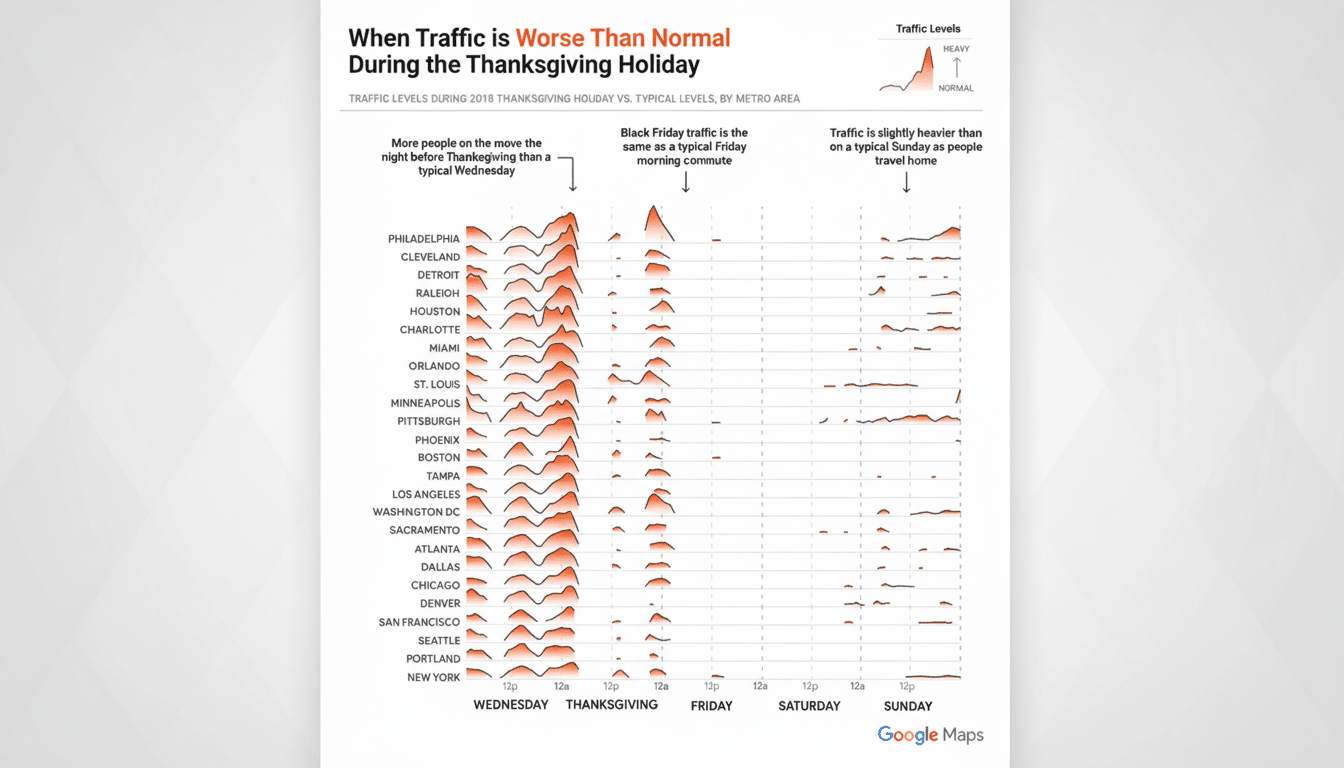
Real-world holiday traffic performance in major metros
Last year, AAA projected that more than 55 million people traveled for Thanksgiving and said about 89 percent of them did so by car. Traffic analytics company INRIX has said Wednesday afternoons (before Thanksgiving) can be as much as 80 percent worse than a normal rush hour in major metros. Those spikes strain every routing engine — and that’s where the differences are made apparent.
When congestion is predictable, Google’s fusion of historical baselines and real-time probe data tends to deliver accurate ETAs and less whipsawing. When an unanticipated multi-vehicle accident closes a lane, Waze often surfaces the fastest workaround right away because drivers ahead of you flagged it mere seconds after it happened.
The catch: Waze’s “shortcut” scheme may leave you stranded on residential streets full of stop signs, speed humps, school zones, or “local traffic only” restrictions. Some city DOTs now mark road closures and restrictions routinely in data provided to navigation apps, but compliance and coverage are hit or miss — while detours can be deadly in strange neighborhoods. In practice, Google Maps’ consistency gets more actual door-to-door wins, while Waze scores more victories when it counts: during truly acute events, like during the chaos of a D.C. snowstorm or a Connecticut post-hurricane situation on dense urban grids.
Navigation features in each app that can shave minutes
Google Maps’ downloadable offline maps keep turn-by-turn guidance and ETAs chugging along when coverage dies on rural interstates. By providing detailed lane guidance, you avoid last-second lane changes that waste time and fuel. Multi-stop planning, HOV/toll options, and “time to leave” notifications help you make the most of your time before you get in the car.
Waze’s “Planned drives” know the expected traffic, too.
On balance, Waze can’t catch up to CoPilot for best-in-class incident and speed camera alerts, vehicle profiles for motorcycles and EVs, and excellent “Planned drives.” Both apps work with Android Auto and Apple CarPlay, and both let you share your ETA with family so the turkey timer can be adjusted accordingly.
Why coverage and offline navigation gaps really matter
Waze needs the signal to get you there, and when it is lost live reports disappear. You go on with your journey, and reroute intelligence decays. Google Maps’ offline mode saves maps, directions, and local search — a considerable boon on mountain passes, rural corridors, and basement garages in stadiums and malls.
Safety considerations and reducing driver cognitive load
NHTSA has warned for years that touching screens raises crash risk. The social DNA of Waze is about interaction — terrific for the network, not so healthy for your attention. Google’s interface is more subdued, with fewer calls to action. Both have voice control; that’s the approach I would take with them in heavy holiday traffic.
Thanksgiving verdict: which navigation app to choose
If what you want is the best chance of arriving sooner, go with Google Maps. Its ETA precision, offline sturdiness, and calmer routing typically trounce Waze’s improvisational approach on holiday corridors. That said, if you’re inching through a metro choke point at rush hour and an unexpected new crash locks down your freeway, Waze can win back minutes on the fly via swift, crowd-sourced detours.
Pro move: As you leave, compare both apps’ ETAs and incident maps, plan your departure time based on that comparison, and download offline areas in Google Maps (just in case).
If you’re able, leave earlier than the late-afternoon peak. It’s hands-free guidance and wise planning that actually get you to dinner at the right hour, whether you roll with Google Maps or Waze.
Sources: AAA holiday travel forecasts, INRIX traffic analyses, city DOTs’ efforts to share data with tech firms like Waze for Cities, and direction from federal safety regulators on in-car distraction.